What Builders and Architects Actually Need from a Detail Survey – A Surveyor’s Perspective
A detail survey is one of the most important documents a builder or architect will work with on any project. It forms the foundation of the design, informs the construction methodology, and underpins almost every technical decision made between the first sketch and the final inspection. Yet it’s also one of the most commonly misunderstood documents in the construction process – particularly when it comes to what it actually needs to contain.
Here’s a practical look at what builders and architects genuinely need from a detail survey, and why getting those details right from the outset makes everyone’s job easier.
Why the Brief Matters
Not all detail surveys are created equal. A survey prepared for a simple single-storey extension on a flat block in suburban Brisbane will look quite different from one prepared for a multi-unit development on a sloping corner site. The licensed surveyor preparing the plan needs to understand how it will be used – and by whom – in order to include everything that’s actually needed.
This is why the brief matters. Before a surveyor sets foot on site, the client, architect, or builder should communicate the nature of the project, the intended use of the survey, and any specific requirements from council or other authorities. A well-briefed surveyor produces a document that works seamlessly for the entire project team. A poorly briefed one may produce a technically accurate survey that still misses critical information.
What Architects Need
For an architect, a detail survey is the canvas on which the entire design is drawn. The more accurate and comprehensive the information, the better the design outcome – and the fewer costly surprises during construction.
Architects typically need the following from a detail survey:
Accurate site boundaries and dimensions. The legal boundary of the site, with precise measurements, is the starting point for everything. Without it, there’s no reliable way to determine setbacks, building envelopes, or how the design relates to neighbouring properties.
Existing structures with dimensions and levels. If there are existing buildings on site – or on adjoining properties close to the boundary – the architect needs to know their position, footprint, height, and floor levels. This is essential for designing extensions, assessing overshadowing, and meeting council setback requirements.
Floor levels of existing structures. Where a project involves an addition or renovation, the floor levels of the existing building need to be captured so the new work can connect seamlessly. Even small level discrepancies can create significant design and construction problems if they’re not identified early.
Tree locations, species, and canopy spread. Trees can significantly affect what can be built and where, particularly where council tree protection overlays or vegetation management requirements apply. Architects need this information to design around significant trees and to demonstrate compliance with relevant planning controls.
Contours at an appropriate interval. For design purposes, contours at 0.2 or 0.5 metre intervals give architects the topographic detail they need to understand how the building will sit on the land, how levels will transition between spaces, and where earthworks or retaining walls may be required.
Easements and encumbrances. Legal constraints on the land – including easements for drainage, services, or access – directly affect what can be built and where. These must be clearly shown on the survey plan.
What Builders Need
While architects are primarily interested in the survey as a design tool, builders approach it from a construction perspective. Their needs overlap with architects in many areas but extend into more practical territory.
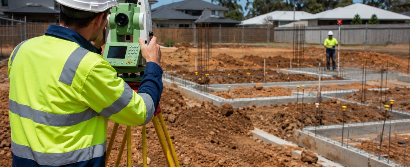
Accurate levels across the entire site. Builders use site levels to plan earthworks, calculate cut-and-fill volumes, design temporary drainage during construction, and set out the building correctly on the ground. The more detailed the level information, the more accurately a builder can price and plan the works.
Location of services. Above-ground evidence of underground services – pits, covers, meters, poles, and the like – needs to be clearly marked. Builders need to know where services enter the site, where they run, and where they may be affected by excavation or construction activity.
Neighbouring structures and levels. Where construction activity is close to a boundary, builders need to understand the relationship between the site and adjoining properties – including any structures, retaining walls, or level changes that may affect shoring, excavation, or waterproofing requirements.
Dimensions that translate to the field. A survey plan is only useful on site if its dimensions can be reliably set out on the ground. Surveyors should ensure that key reference points – boundaries, structures, service pits – are tied to a coordinate system that allows a builder to set out the works accurately.
The Common Gaps
The most frequent complaints from architects and builders about detail surveys come down to a handful of recurring issues: contour intervals that are too coarse for the complexity of the site, missing floor levels on existing structures, trees that aren’t identified to species, and neighbouring context that stops too abruptly at the boundary.
None of these omissions reflect poor surveying – they typically reflect a brief that didn’t communicate what the project actually needed. The solution is straightforward: before commissioning a survey, have a conversation with your surveyor about the project, the design team’s requirements, and any council-specific deliverables. A few minutes of clarity at the start of the process produces a document that serves the entire project team, from the first design sketch to the final construction sign-off.